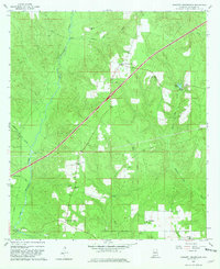
1960 Map of Barnett Crossroads
USGS Topo · Published 1981About this map
Barnett Crossroads and Stanley Crossroads serve as the primary hubs in this Escambia County landscape, reflecting the rural settlement patterns of the early 1960s. The region is defined by the winding course of Big Escambia Creek, which is spanned by local landmarks such as Gressett Bridge and Sardine Bridge. The L & N RR cuts a diagonal path through the terrain, indicating the historical reliance on rail for transporting timber or agricultural goods. Small community centers are anchored by numerous country churches, including New Bethlehem Ch and Canaan Ch, which often stand alongside local burial grounds like Emmons Cem. The presence of the Maschmeyer Lookout Tower suggests a landscape managed for forest resources, while scattered Gravel Pit operations point to local extraction industries during this era.
Find a feature on this map
26 named features on this map. Tap any name to fly to it.
Don’t see what you’re looking for? This feature index may not catch every label — zoom into the map to look around manually.
Map Details
Editions of this 1960 Barnett Crossroads Map
3 editions found
Other maps of this area

1953 · Andalusia
USGS Topo · 1:250,000

1957 · Andalusia
USGS Topo · 1:250,000

1960 · Atmore
USGS Topo · 1:24,000

1960 · Huxford
USGS Topo · 1:24,000

1960 · Pollard
USGS Topo · 1:24,000

1960 · Barnett Crossroads
USGS Topo · 1:24,000

1960 · Wallace
USGS Topo · 1:24,000
1960 · Flomaton
USGS Topo · 1:24,000

1971 · Range
USGS Topo · 1:24,000

1972 · Frisco City SE
USGS Topo · 1:24,000