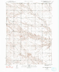
1948 Map of Barrel Springs Creek North
USGS Topo · Published 1993About this map
Nonpareil and Liberty townships define the open high plains of Box Butte County in this mid-century survey. The landscape is marked by a network of rural schoolhouse sites, including School No 27, School No 51, and School No 19, which served the scattered farmsteads across Wright and Snake Creek. Water is the primary shaper of the terrain here, most notably seen at the Point of Rocks where the elevation drops toward the drainage of Barrel Springs Creek and its South Branch. Numerous windmills dot the sections, indicating the vital reliance on groundwater for agriculture and livestock in this semi-arid region. The map captures a moment when rural infrastructure was still centered around these numbered school districts, providing a precise spatial record for family historians and geographers of the Nebraska panhandle.
Find a feature on this map
13 named features on this map. Tap any name to fly to it.
Don’t see what you’re looking for? This feature index may not catch every label — zoom into the map to look around manually.
Map Details
Editions of this 1948 Barrel Springs Creek North Map
3 editions found
Other maps of this area

1946 · Nonpareil
USGS Topo · 1:24,000

1948 · Hemingford
USGS Topo · 1:24,000

1948 · Hemingford 4 SW
USGS Topo · 1:24,000

1948 · Hemingford 4 SE
USGS Topo · 1:24,000

1948 · Hemingford 4 NE
USGS Topo · 1:24,000

1948 · Hemingford 4 NW
USGS Topo · 1:24,000

1948 · Nonpareil
USGS Topo · 1:24,000

1951 · Marsland
USGS Topo · 1:62,500

1951 · Kilpatrick Lake
USGS Topo · 1:62,500

1955 · Alliance
USGS Topo · 1:250,000