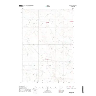
2020 Map of Barren Butte
USGS Topo · Published 2020About this map
Barren Butte rises as a central landmark within the Fort Yates District of Sioux County, North Dakota, in this topographic study. The landscape is defined by the winding course of Porcupine Creek as it cuts across the northern and eastern portions of the quadrangle, while Stone Man Creek drains the southeastern corner. These drainages reveal a terrain of high plateaus and eroded breaks characteristic of the region west of the Missouri River.
Find a feature on this map
7 named features on this map. Tap any name to fly to it.
Don’t see what you’re looking for? This feature index may not catch every label — zoom into the map to look around manually.
Map Details
Editions of this 2020 Barren Butte Map
This is the sole edition of this map. No revisions or reprints were ever made.
Other maps of this area

1954 · Bismarck
USGS Topo · 1:250,000

1958 · Bismarck
USGS Topo · 1:250,000

1968 · Fort Yates NW
USGS Topo · 1:24,000

1968 · Fort Yates
USGS Topo · 1:24,000

1968 · Cannon Ball SW
USGS Topo · 1:24,000

1971 · Barren Butte
USGS Topo · 1:24,000

1971 · Half Timber Butte
USGS Topo · 1:24,000

1971 · Froelich Dam
USGS Topo · 1:24,000

1971 · Solen SW
USGS Topo · 1:24,000
1971 · Selfridge SE
USGS Topo · 1:24,000