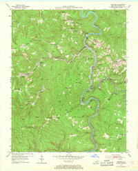
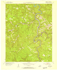
1954 Map of Barthell
USGS Topo · Published 1968About this map
The South Fork Cumberland River carves a deep path through the coal-rich landscape of the Cumberland National Forest, dictating the placement of early mining and timber settlements. In the mid-1950s, the Kentucky and Tennessee Railway remained the vital artery for this region, winding past coal camps like Barthell and Blue Heron. The rugged topography of Rattlesnake Ridge and Coon Patch Ridge isolated many small communities, leading to a proliferation of local institutions such as White Oak Sch and Wolf Ridge Ch. Genealogists will find a wealth of family history in the numerous small burial grounds, including Chitwood Cem, Hickman Cem, and the uniquely named Nancy Grave Cem, which dot the ridges and hollows of McCreary County.
Find a feature on this map
93 named features on this map. Tap any name to fly to it.
Don’t see what you’re looking for? This feature index may not catch every label — zoom into the map to look around manually.
Map Details
Editions of this 1954 Barthell Map
3 editions found
Other maps of this area

1890 · Williamsburg
USGS Topo · 1:125,000

1894 · Williamsburg
USGS Topo · 1:125,000

1932 · Burnside
USGS Topo · 1:62,500

1934 · Barthell
USGS Topo · 1:62,500

1952 · Wiborg
USGS Topo · 1:24,000

1952 · Whitley City
USGS Topo · 1:24,000
1953 · Winfield
USGS Topo · 1:24,000

1954 · Coopersville
USGS Topo · 1:24,000
1954 · Nevelsville
USGS Topo · 1:24,000
1954 · Barthell
USGS Topo · 1:24,000