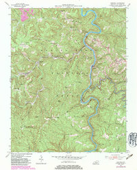
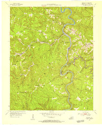
1954 Map of Barthell
USGS Topo · Published 1983About this map
The South Fork Cumberland River winds through the heart of the Daniel Boone National Forest, shaping a landscape defined by sharp ridges and deep hollows. In the 1950s, the industrial life of this region was anchored by the Kentucky and Tennessee RR, which traced the river and its tributaries to serve coal and timber interests. Settlements such as Barthell, Yamacraw, and Smith Town are situated along these transit corridors, while more remote communities like Co-Operative and White Oak Junction occupy the upland gaps. Local history is deeply etched into the terrain through family and community landmarks, including the Winchester Cem and various schools like Nancy Grave Sch and Wolf Creek Sch. The geography reveals a classic Appalachian pattern where transport, industry, and social life — represented by Wilson Ridge Ch and Beech Grove Ch — are bound to the narrow navigable valleys and protected hollows.
Find a feature on this map
94 named features on this map. Tap any name to fly to it.
Don’t see what you’re looking for? This feature index may not catch every label — zoom into the map to look around manually.
Map Details
Editions of this 1954 Barthell Map
3 editions found
Other maps of this area

1890 · Williamsburg
USGS Topo · 1:125,000

1894 · Williamsburg
USGS Topo · 1:125,000

1932 · Burnside
USGS Topo · 1:62,500

1934 · Barthell
USGS Topo · 1:62,500

1952 · Wiborg
USGS Topo · 1:24,000

1952 · Whitley City
USGS Topo · 1:24,000
1953 · Winfield
USGS Topo · 1:24,000

1954 · Coopersville
USGS Topo · 1:24,000
1954 · Nevelsville
USGS Topo · 1:24,000
1954 · Barthell
USGS Topo · 1:24,000