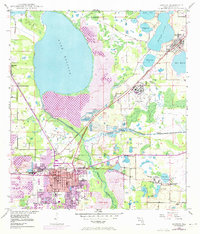
1949 Map of Bartow
USGS Topo · Published 1973About this map
The city of Bartow serves as the focal point of this Central Florida survey, appearing at a time of significant transition as documented by aerial photography from the 1940s and revisions from the early 1970s. The landscape is defined by the heavy presence of the phosphate industry, with numerous Strip Mine operations and excavations altering the terrain north and east of the city. Water dominates the geography, from the expansive Lake Hancock and Eagle Lake to the winding course of the Peace River and Saddle Creek. Local heritage is well-preserved through detailed labeling of institutional landmarks such as the Summerlin Institute and Union Academy, along with several family and community burial grounds like Oak Hill Cem and Glover Cem. The infrastructure of the Seaboard Coast Line railroad provides a clear window into the logistical network that supported the region's mines and groves.
Find a feature on this map
58 named features on this map. Tap any name to fly to it.
Don’t see what you’re looking for? This feature index may not catch every label — zoom into the map to look around manually.
Map Details
Editions of this 1949 Bartow Map
5 editions found
Other maps of this area

1944 · Lakeland
USGS Topo · 1:31,680

1944 · Auburndale
USGS Topo · 1:31,680

1949 · Mulberry
USGS Topo · 1:24,000

1949 · Bartow
USGS Topo · 1:24,000

1949 · Bradley Junction
USGS Topo · 1:24,000

1950 · Mulberry
USGS Topo · 1:24,000

1950 · Bartow
USGS Topo · 1:24,000

1950 · Bradley Junction
USGS Topo · 1:24,000

1952 · Homeland
USGS Topo · 1:24,000

1955 · Eloise
USGS Topo · 1:24,000