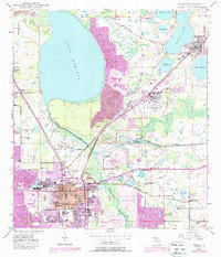
1949 Map of Bartow
USGS Topo · Published 1988About this map
Bartow sits at the heart of this landscape, serving as a hub where the Seaboard Coast Line railroad and local thoroughfares like Stuart St and Lovers Lane converge. The area’s educational and community foundations are visible through sites like Union Academy and the Summerlin Institute, alongside numerous burial grounds such as Oak Hill Cem and Wildwood Cemetery. To the north, the massive expanse of Lake Hancock dominates the terrain, while the Peace River and Saddle Creek define the hydrological character of the region. A significant industrial footprint is evident in the widespread reclaimed strip mines that surround the city, marking the extensive phosphate mining history of Polk County. Smaller settlements and neighborhoods like Gordonville, Phyllis, and Connersville are scattered across the quadrangle, illustrating the distributed residential patterns of the mid-20th century.
Find a feature on this map
55 named features on this map. Tap any name to fly to it.
Don’t see what you’re looking for? This feature index may not catch every label — zoom into the map to look around manually.
Map Details
Editions of this 1949 Bartow Map
5 editions found
Other maps of this area

1944 · Lakeland
USGS Topo · 1:31,680

1944 · Auburndale
USGS Topo · 1:31,680

1949 · Mulberry
USGS Topo · 1:24,000

1949 · Bartow
USGS Topo · 1:24,000

1949 · Bradley Junction
USGS Topo · 1:24,000

1950 · Mulberry
USGS Topo · 1:24,000

1950 · Bartow
USGS Topo · 1:24,000

1950 · Bradley Junction
USGS Topo · 1:24,000

1952 · Homeland
USGS Topo · 1:24,000

1955 · Eloise
USGS Topo · 1:24,000