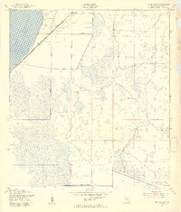
1953 Map of Basinger SW
USGS Topo · Published 1954About this map
Lake Istokpoga dominates the northwest corner of this 1950s survey, its shoreline defined by a massive Levee system that reflects the era's significant hydraulic engineering efforts in Highlands County. The Seaboard Air Line railway cuts across the landscape, connecting the small settlement of Marland to the broader regional network. This map provides a detailed look at the rural drainage patterns of the Florida interior during a period of transition, where the natural wetlands were being managed through features like the Indian Prairie Canal. Scattered landmarks such as a Flowing Well and Wild Island punctuate the vast, low-lying terrain, offering specific points of interest for those tracing the historical geography of this section of the state. The prevalence of windmills throughout the central and eastern portions highlights the reliance on groundwater for agriculture and local life in this period.
Find a feature on this map
9 named features on this map. Tap any name to fly to it.
Don’t see what you’re looking for? This feature index may not catch every label — zoom into the map to look around manually.
Map Details
Editions of this 1953 Basinger SW Map
3 editions found
Other maps of this area

1952 · Lake Placid
USGS Topo · 1:24,000

1952 · Lorida
USGS Topo · 1:24,000

1953 · Basinger
USGS Topo · 1:24,000

1953 · Brighton NW
USGS Topo · 1:24,000

1953 · Fort Basinger
USGS Topo · 1:24,000

1953 · Brighton
USGS Topo · 1:24,000

1953 · Basinger SW
USGS Topo · 1:24,000

1953 · Basinger NW
USGS Topo · 1:24,000

1953 · Childs
USGS Topo · 1:24,000

1956 · Fort Pierce
USGS Topo · 1:250,000