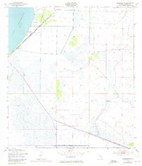
1953 Map of Basinger SW
USGS Topo · Published 1973About this map
The marshy shoreline of Lake Istokpoga dominates the northwestern corner of this landscape, where the settlement of Marland sits along an Old Railroad Grade. This mid-century survey by the Corps of Engineers highlights a transition in Florida's water management, revealing a complex network of infrastructure including the Indian Prairie Canal, Canal C-41, and Canal C-41A. These waterways are supported by a system of earthen Levee works and Lock 3, designed to regulate the wet prairie and former wetlands for agricultural or development purposes. To the north, the isolated cluster of Wild Island rises above the surrounding flat terrain, while scattered Windmill sites and a Flowing Well suggest the rural, resource-dependent character of the region during the early 1950s. The presence of the former rail line near Marland indicates a shift from earlier rail-based transportation to the managed hydraulic landscape seen today.
Find a feature on this map
13 named features on this map. Tap any name to fly to it.
Don’t see what you’re looking for? This feature index may not catch every label — zoom into the map to look around manually.
Map Details
Editions of this 1953 Basinger SW Map
3 editions found
Other maps of this area

1952 · Lake Placid
USGS Topo · 1:24,000

1952 · Lorida
USGS Topo · 1:24,000

1953 · Basinger
USGS Topo · 1:24,000

1953 · Brighton NW
USGS Topo · 1:24,000

1953 · Fort Basinger
USGS Topo · 1:24,000

1953 · Brighton
USGS Topo · 1:24,000

1953 · Basinger SW
USGS Topo · 1:24,000

1953 · Basinger NW
USGS Topo · 1:24,000

1953 · Childs
USGS Topo · 1:24,000

1956 · Fort Pierce
USGS Topo · 1:250,000