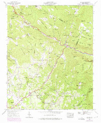
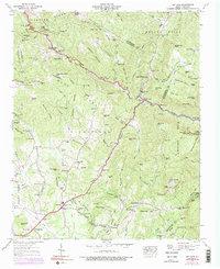
1946 Map of Bat Cave
USGS Topo · Published 1975About this map
Hickorynut Gap serves as a prominent mountain passage in this mid-century landscape where Buncombe, Henderson, Rutherford, and Polk counties converge. The rugged topography is defined by the Blue Ridge Divide, separating the Tennessee Valley from the upper reaches of the Broad River. Local life centers around the small settlements of Bat Cave and Edneyville, with numerous country houses of worship like St Pauls Ch and Mt Moriah Ch dotting the winding roads. The geography reveals a transition from agricultural activity near Maxwell Mill to the steeper elevations of Bearwallow Mtn. Notable landmarks of the era include the Lookout Tower and a dedicated FAA Tracking Station situated atop Sugarloaf Mtn. This document captures the complex hydrology of the region, from the dramatic Cascades and Rainbow Falls to the various creeks that feed into the Hungry River.
Find a feature on this map
105 named features on this map. Tap any name to fly to it.
Don’t see what you’re looking for? This feature index may not catch every label — zoom into the map to look around manually.
Map Details
Editions of this 1946 Bat Cave Map
6 editions found

Other maps of this area

1900 · Mount Mitchell
USGS Topo · 1:125,000

1902 · Mount Mitchell
USGS Topo · 1:125,000

1907 · Saluda
USGS Topo · 1:125,000

1935 · Batcave
USGS Topo · 1:24,000

1935 · Hendersonville
USGS Topo · 1:24,000

1935 · Black Mountain
USGS Topo · 1:24,000

1935 · Fishtop
USGS Topo · 1:24,000

1936 · Fruitland
USGS Topo · 1:24,000

1941 · Black Mountain
USGS Topo · 1:24,000

1942 · Fruitland
USGS Topo · 1:24,000