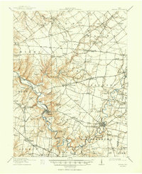
1916 Map of Batavia
USGS Topo · Published 1950About this map
Batavia and Williamsburg anchor this survey of Clermont County, centered on the winding course of the East Fork Little Miami River. The landscape is a network of small agricultural settlements and rural schoolhouses, such as Manila School and Sugar Grove School, reflecting the dense rural population of the early twentieth century. Extensive rail infrastructure connects these communities to the larger region, including the Cincinnati and Portsmouth Electric RR and the Norfolk and Western RR.
Find a feature on this map
118 named features on this map. Tap any name to fly to it.
Don’t see what you’re looking for? This feature index may not catch every label — zoom into the map to look around manually.
Map Details
Editions of this 1916 Batavia Map
4 editions found
Other maps of this area

1898 · East Cincinnati
USGS Topo · 1:62,500

1904 · Mason
USGS Topo · 1:62,500

1906 · Mason
USGS Topo · 1:62,500

1907 · Blanchester
USGS Topo · 1:62,500

1914 · East Cincinnati
USGS Topo · 1:62,500

1914 · Batavia
USGS Topo · 1:48,000

1914 · Morrow
USGS Topo · 1:62,500

1916 · Batavia
USGS Topo · 1:62,500

1916 · Morrow
USGS Topo · 1:62,500

1917 · Sardinia
USGS Topo · 1:62,500