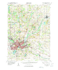
1950 Map of Battle Creek
USGS Topo · Published 1950About this map
Battle Creek serves as a dense industrial and rail hub in this mid-century study, centered at the confluence of the Kalamazoo River and its namesake stream. The landscape is heavily marked by the infrastructure of the era, from the sprawling Kellogg Air Base to the dual rail lines of the Michigan Central RR and Grand Trunk RR that dictate the city's growth. Residential expansion is evident in neighborhoods like Urbandale and Verona, while the surrounding townships of Pennfield and Bedford remain a patchwork of small school districts and family-named corners.
Find a feature on this map
122 named features on this map. Tap any name to fly to it.
Don’t see what you’re looking for? This feature index may not catch every label — zoom into the map to look around manually.
Map Details
Editions of this 1950 Battle Creek Map
3 editions found

Other maps of this area

1918 · Battle Creek
USGS Topo · 1:62,500

1918 · Union City
USGS Topo · 1:62,500

1918 · Galesburg
USGS Topo · 1:62,500

1918 · Leonidas
USGS Topo · 1:62,500

1921 · Marshall
USGS Topo · 1:62,500

1923 · Marshall
USGS Topo · 1:62,500

1943 · Battle Creek
USGS Topo · 1:62,500

1943 · Marshall
USGS Topo · 1:62,500

1944 · Leonidas
USGS Topo · 1:62,500

1944 · Galesburg
USGS Topo · 1:62,500