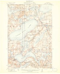
1914 Map of Battle Lake
USGS Topo · Published 1914About this map
Glacial lakes and small resort-era camps define this landscape in the heart of Otter Tail County. The sprawling Otter Tail Lake and Dead Lake dominate the northern half, where early twentieth-century travel was facilitated by the Minneapolis and St. Marie Ry. and the Northern Pacific Ry. passing through Richville. Along the shores of smaller water bodies, seasonal settlements such as Camp Nidaros, Balmoral, and Mamechoka Camp reflect the region's burgeoning identity as a summer destination. To the south, the village of Battle Lake serves as a hub near Lake Blanche and Annie Battle Lake. The map reveals a dense network of early rural infrastructure, including Town Hall and nearly twenty numbered schools like School No 174, providing a window into the organized settlement of townships like Everts and Girard before modern lakefront development altered the landscape.
Find a feature on this map
86 named features on this map. Tap any name to fly to it.
Don’t see what you’re looking for? This feature index may not catch every label — zoom into the map to look around manually.
Map Details
Editions of this 1914 Battle Lake Map
3 editions found
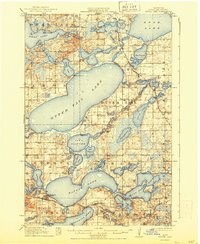
Other maps of this area

1912 · Vergas
USGS Topo · 1:62,500

1912 · Battle Lake
USGS Topo · 1:62,500

1913 · Ashby
USGS Topo · 1:62,500

1914 · Battle Lake
USGS Topo · 1:62,500

1915 · Underwood
USGS Topo · 1:62,500

1915 · Perham
USGS Topo · 1:62,500

1915 · Vergas
USGS Topo · 1:62,500

1953 · Brainerd
USGS Topo · 1:250,000

1957 · Brainerd
USGS Topo · 1:250,000

1958 · Brainerd
USGS Topo · 1:250,000