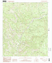
1991 Map of Bear Mountain
USGS Topo · Published 1991About this map
Apache National Forest lands dominate this portion of Greenlee County, where the Blue River winds through a complex system of deep canyons and high mesas. The landscape is defined by its water sources, from the curiously named Ice Cream Cone Spring and Still Spring Still to the more expansive Thomas Lake at Cole Flat. This terrain, while largely unpopulated, shows the marks of early Forest Service activity and cattle ranching, anchored by the Blue Camp FS Station and Lee Ranch.
Find a feature on this map
71 named features on this map. Tap any name to fly to it.
Don’t see what you’re looking for? This feature index may not catch every label — zoom into the map to look around manually.
Map Details
Editions of this 1991 Bear Mountain Map
2 editions found
Other maps of this area

1913 · Morenci
USGS Topo · 1:125,000

1915 · Morenci
USGS Topo · 1:125,000

1922 · Nutrioso
USGS Topo · 1:125,000

1954 · Clifton
USGS Topo · 1:250,000

1957 · Clifton
USGS Topo · 1:250,000

1958 · Clifton
USGS Topo · 1:250,000

1958 · Hannagan Meadow
USGS Topo · 1:62,500

1961 · Blue
USGS Topo · 1:62,500

1962 · Clifton
USGS Topo · 1:250,000
1967 · Alma Mesa
USGS Topo · 1:24,000