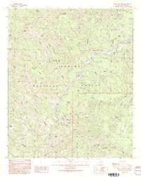
1991 Map of Bear Mountain
USGS Topo · Published 1991About this map
The Blue River carves a deep path through the heart of the Apache National Forest in this 1991 provisional survey, documenting a landscape defined by high mesas and isolated ranching outposts. The winding watercourse is the primary corridor for human activity, connecting the Les Ranch settlement with the river crossing at Balke Crossing. In the higher elevations to the east, the Blue Camp FS Station and a nearby Lookout Tower indicate the importance of forest management and fire surveillance in this heavily timbered region.
Find a feature on this map
54 named features on this map. Tap any name to fly to it.
Don’t see what you’re looking for? This feature index may not catch every label — zoom into the map to look around manually.
Map Details
Editions of this 1991 Bear Mountain Map
2 editions found
Other maps of this area

1913 · Morenci
USGS Topo · 1:125,000

1915 · Morenci
USGS Topo · 1:125,000

1922 · Nutrioso
USGS Topo · 1:125,000

1954 · Clifton
USGS Topo · 1:250,000

1957 · Clifton
USGS Topo · 1:250,000

1958 · Clifton
USGS Topo · 1:250,000

1958 · Hannagan Meadow
USGS Topo · 1:62,500

1961 · Blue
USGS Topo · 1:62,500

1962 · Clifton
USGS Topo · 1:250,000
1967 · Alma Mesa
USGS Topo · 1:24,000