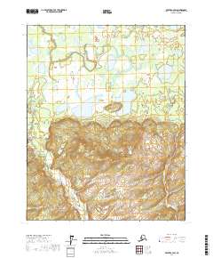
2017 Map of Beaver A-3 SW
USGS Topo · Published 2017About this map
Old Lost Creek winds through a complex system of interior wetlands and low-lying drainage basins in this remote portion of the Yukon-Koyukuk region. The landscape is defined by its water-saturated terrain, where Old Lost Cr and Alfred Cr navigate between numerous unnamed ponds and marshy depressions. This topographic detail reflects the characteristic permafrost-influenced hydrology of the Alaskan interior, showing how drainage patterns shift across the flat alluvial plains. The absence of roads or permanent settlements emphasizes the wilderness character of the area, making this survey a vital record of the natural watershed before potential environmental shifts or future land-use changes. It provides a precise look at the township and range boundaries, including t15n r4w and t14n r4w, which are essential for identifying specific land tracts in this vast, roadless territory.
Find a feature on this map
9 named features on this map. Tap any name to fly to it.
Don’t see what you’re looking for? This feature index may not catch every label — zoom into the map to look around manually.
Map Details
Editions of this 2017 Beaver A-3 SW Map
This is the sole edition of this map. No revisions or reprints were ever made.
Other maps of this area

1945 · Livengood
USGS Topo · 1:250,000

1951 · Livengood
USGS Topo · 1:250,000

1951 · Beaver
USGS Topo · 1:250,000

1951 · Livengood D-3
USGS Topo · 1:63,360

1953 · Livengood D-4
USGS Topo · 1:63,360

1954 · Livengood D-4
USGS Topo · 1:63,360
1954 · Livengood D-3
USGS Topo · 1:63,360

1956 · Beaver A-3
USGS Topo · 1:63,360

1956 · Beaver
USGS Topo · 1:250,000

1956 · Beaver A-4
USGS Topo · 1:63,360