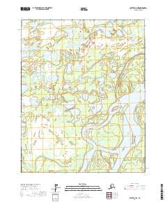
2017 Map of Beaver A-4 NE
USGS Topo · Published 2017About this map
The Yukon River dominates the southeastern portion of this map, winding through a complex system of islands and sandbars including Gull Island and Moose Island. This portion of the Yukon Flats illustrates a highly dynamic riverine environment where the water's path is defined by landmarks such as Jacob Point. North of the main river channel, the landscape transitions into a watery wilderness of marshlands and small ponds, notable for the paired basins of Twin Lakes. These interior wetlands are drained by a network of small waterways, most notably Meadow Creek and Pat Cr, which cut through the low-lying terrain. The presence of Old Lost Creek at the eastern edge suggests the shifting nature of the drainage patterns in this subarctic flood plain. This topography reflects the isolation and natural hydrology of the Interior Alaska region, where the river remains the primary geographic anchor.
Find a feature on this map
14 named features on this map. Tap any name to fly to it.
Don’t see what you’re looking for? This feature index may not catch every label — zoom into the map to look around manually.
Map Details
Editions of this 2017 Beaver A-4 NE Map
This is the sole edition of this map. No revisions or reprints were ever made.
Other maps of this area

1951 · Beaver
USGS Topo · 1:250,000

1956 · Beaver B-3
USGS Topo · 1:63,360

1956 · Beaver A-3
USGS Topo · 1:63,360

1956 · Beaver
USGS Topo · 1:250,000

1956 · Beaver A-4
USGS Topo · 1:63,360

1956 · Beaver B-4
USGS Topo · 1:63,360

1964 · Beaver
USGS Topo · 1:250,000
2017 · Beaver A-3 NW
USGS Topo · 1:25,000
2017 · Beaver B-3 SW
USGS Topo · 1:25,000
2017 · Beaver A-4 SE
USGS Topo · 1:25,000