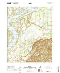
2017 Map of Beaver A-4 SE
USGS Topo · Published 2017About this map
The Yukon River dominates the western and northern reaches of this landscape, its expansive braided channels and shifting sediment creating a complex network of waterways. Centrally located within these waters is Jokinaugh Island, a large landmass surrounded by the river's main flow and secondary channels. To the west, Long Point juts into the current, serving as a distinct landmark along the riverbank.
Find a feature on this map
10 named features on this map. Tap any name to fly to it.
Don’t see what you’re looking for? This feature index may not catch every label — zoom into the map to look around manually.
Map Details
Editions of this 2017 Beaver A-4 SE Map
This is the sole edition of this map. No revisions or reprints were ever made.
Other maps of this area

1945 · Livengood
USGS Topo · 1:250,000

1951 · Livengood
USGS Topo · 1:250,000

1951 · Beaver
USGS Topo · 1:250,000

1951 · Livengood D-3
USGS Topo · 1:63,360

1953 · Livengood D-4
USGS Topo · 1:63,360

1954 · Livengood D-4
USGS Topo · 1:63,360
1954 · Livengood D-3
USGS Topo · 1:63,360

1956 · Beaver A-3
USGS Topo · 1:63,360

1956 · Beaver
USGS Topo · 1:250,000

1956 · Beaver A-4
USGS Topo · 1:63,360