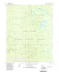
1970 Map of Beaver A-6
USGS Topo · Published 1987About this map
Guishiemana Lake and the complex hydrology of the Yukon Flats define this subarctic interior landscape. Recorded through aerial photography in 1970, the area shows a vast network of unnamed ponds and interconnected waterways, including the Dall River, Little Dall River, and the Sussaymin Lakes system. To the south, the topography shifts abruptly into the Fort Hamlin Hills, where prominent elevations like Nokuy rise above the alluvial plain. The map documents a sparse human imprint on the land, most notably the seasonal Winter Trail cutting across the north and the designation of the National Wildlife Refuge, which encompasses a significant portion of these wetlands. This survey provides a baseline of the regional terrain before modern environmental shifts, capturing the precise drainage patterns of Hamlin Creek and its surroundings.
Find a feature on this map
10 named features on this map. Tap any name to fly to it.
Don’t see what you’re looking for? This feature index may not catch every label — zoom into the map to look around manually.
Map Details
Editions of this 1970 Beaver A-6 Map
2 editions found
Other maps of this area

1945 · Livengood
USGS Topo · 1:250,000

1951 · Bettles
USGS Topo · 1:250,000

1951 · Tanana
USGS Topo · 1:250,000

1951 · Livengood
USGS Topo · 1:250,000

1951 · Beaver
USGS Topo · 1:250,000

1952 · Livengood D-5
USGS Topo · 1:63,360

1956 · Bettles
USGS Topo · 1:250,000

1956 · Beaver A-5
USGS Topo · 1:63,360

1956 · Beaver B-5
USGS Topo · 1:63,360

1956 · Beaver
USGS Topo · 1:250,000