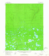
1956 Map of Beaver B-4
USGS Topo · Published 1964About this map
Tulebagh Lake and the surrounding wetlands define this subarctic landscape during the mid-1950s. The region is dominated by an intricate network of water bodies, including Tanjoga Lake, Clochacohua Lake, and the smaller Fishnets Lake. These features, along with the proximity of The Forks, suggest a seasonal landscape utilized by local inhabitants for subsistence, as evidenced by a lonely Cabin located near the eastern shore of Tanjoga Lake. The hydrology is further shaped by the East Fork, which drains through the northern hilly terrain before meeting the complex lake system below.
Find a feature on this map
8 named features on this map. Tap any name to fly to it.
Don’t see what you’re looking for? This feature index may not catch every label — zoom into the map to look around manually.
Map Details
Editions of this 1956 Beaver B-4 Map
3 editions found
Other maps of this area

1951 · Beaver
USGS Topo · 1:250,000

1956 · Beaver A-5
USGS Topo · 1:63,360

1956 · Beaver B-3
USGS Topo · 1:63,360

1956 · Beaver A-3
USGS Topo · 1:63,360

1956 · Beaver B-5
USGS Topo · 1:63,360

1956 · Beaver
USGS Topo · 1:250,000

1956 · Beaver A-4
USGS Topo · 1:63,360

1956 · Beaver B-4
USGS Topo · 1:63,360

1964 · Beaver
USGS Topo · 1:250,000
1970 · Beaver C-5
USGS Topo · 1:63,360