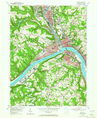
1953 Map of Beaver
USGS Topo · Published 1966About this map
The Ohio River and Beaver River form the industrial and geographic heart of this mid-century survey, where the confluence at Rochester and Bridgewater marks a critical node in Pennsylvania's transportation network. The landscape is defined by the massive rail infrastructure of the Pennsylvania and Erie lines, including the sprawling Conway Yard to the southeast. Heavily developed riverfronts in Beaver Falls, New Brighton, and Monaca contrast with the medical and social institutions that dot the higher ground, such as the Passavant Memorial Homes and the Beaver County Home and Hospital. Industrial signatures are found in the Brick Kilns near Vanport and the Slag Dump at Aliquippa, reflecting the region's manufacturing dominance. Away from the water, smaller communities like Marion Hill and Patterson Hts occupy the ridges, while the Beaver Valley Interchange signals the rising influence of the Pennsylvania Turnpike on the local terrain.
Find a feature on this map
110 named features on this map. Tap any name to fly to it.
Don’t see what you’re looking for? This feature index may not catch every label — zoom into the map to look around manually.
Map Details
Editions of this 1953 Beaver Map
4 editions found
Other maps of this area

1901 · Beaver
USGS Topo · 1:62,500

1902 · New Castle
USGS Topo · 1:62,500

1904 · Newcastle
USGS Topo · 1:62,500

1904 · Beaver
USGS Topo · 1:62,500

1906 · Sewickley
USGS Topo · 1:62,500

1908 · Sewickley
USGS Topo · 1:62,500

1908 · Zelienople
USGS Topo · 1:62,500

1910 · Zelienople
USGS Topo · 1:62,500

1951 · Canton
USGS Topo · 1:250,000

1953 · Canton
USGS Topo · 1:250,000