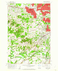
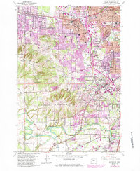
1961 Map of Beaverton
USGS Topo · Published 1961About this map
Beaverton and its surrounding suburban communities show significant growth in the early sixties, anchored by the Oregon Electric and Southern Pacific railroad lines. The landscape is a mix of developing residential tracts like Cedar Hills and older landmarks such as St Marys Boys Home. To the south, the Tualatin River meanders through lower elevations near Onion Flat, while the northern portion of the map is defined by the prominent heights of Sexton Mtn and Cooper Mtn. This period captures a shift from agricultural land to structured townships, evidenced by the many schools like Merle Davies High Sch and Jesuit High Sch appearing alongside traditional sites like Crescent Grove Cem. Aviation history is present at Bernard Airport, serving the region before the further encroachment of the metropolitan sprawl seen in the dense red-tinted sectors of West Slope and Raleigh Hills.
Find a feature on this map
57 named features on this map. Tap any name to fly to it.
Don’t see what you’re looking for? This feature index may not catch every label — zoom into the map to look around manually.
Map Details
Editions of this 1961 Beaverton Map
5 editions found
Other maps of this area

1897 · Portland
USGS Topo · 1:62,500

1905 · Portland
USGS Topo · 1:62,500

1914 · Oregon City
USGS Topo · 1:62,500

1915 · Hillsboro
USGS Topo · 1:62,500

1916 · Tualatin
USGS Topo · 1:62,500

1918 · Hillsboro
USGS Topo · 1:62,500

1939 · Oregon City
USGS Topo · 1:62,500

1939 · Tualatin
USGS Topo · 1:62,500

1940 · Tualatin
USGS Topo · 1:62,500

1940 · Hillsboro
USGS Topo · 1:62,500