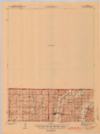
1943 Map of Bedford
USGS Topo · Published 1943About this map
The Chicago Great Western railroad cuts through the heart of this borderland, connecting the hub of Sheridan to the surrounding rural townships just before the mid-century. This 1940 survey by E. J. Fennell reveals a landscape densely populated with small schoolhouse districts, including Maple Grove Sch, Luteston SCH, and the curiously named Star of the West Sch. The terrain is defined by the winding paths of the Platte River and Grand River, which drain the rolling hills of Independence and Union townships. Along the state line, small settlements like Athelstan and Isadora serve as local anchors. Notable for genealogists are the well-marked burial grounds, such as New Hope Cem and Luteston Cem, which offer precise locations for ancestral homesteads in this agricultural region of Missouri and Iowa.
Find a feature on this map
46 named features on this map. Tap any name to fly to it.
Don’t see what you’re looking for? This feature index may not catch every label — zoom into the map to look around manually.
Map Details
Editions of this 1943 Bedford Map
2 editions found
Other maps of this area

1940 · Blockton
USGS Topo · 1:62,500

1940 · Bedford
USGS Topo · 1:62,500

1940 · New Market
USGS Topo · 1:62,500

1940 · Parnell
USGS Topo · 1:62,500

1942 · Grant City
USGS Topo · 1:62,500

1943 · Bedford
USGS Topo · 1:62,500

1943 · Parnell
USGS Topo · 1:62,500

1943 · Maryville
USGS Topo · 1:62,500

1943 · New Market
USGS Topo · 1:62,500

1943 · Grant City
USGS Topo · 1:62,500