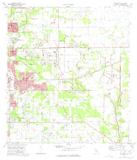
1973 Map of Bee Ridge
USGS Topo · Published 1975About this map
Suburban expansion and agricultural history meet in this mid-1970s survey of eastern Sarasota. The landscape shows a transition from the established community at Fruitville and the residential clusters of Sunnyland toward the interior marshlands and newer developments near Lake Sarasota. The Seaboard Coast Line railroad cuts through the terrain, serving as a primary corridor alongside major thoroughfares like Bee Ridge Road and Palmer Boulevard. Local infrastructure of the era is well-documented, including several radio towers, the drive-in theater, and a sewage disposal plant. For those tracing local history, the map identifies specific educational and civic sites such as the Sarasota Sch, Wood Sch, and the County Cem. Further east, the character of the land becomes more open, defined by features like the Slough and various drainage patterns that hint at the region's original wetland environment before extensive modern drainage.
Find a feature on this map
47 named features on this map. Tap any name to fly to it.
Don’t see what you’re looking for? This feature index may not catch every label — zoom into the map to look around manually.
Map Details
Editions of this 1973 Bee Ridge Map
3 editions found
Other maps of this area

1943 · Laurel
USGS Topo · 1:24,000

1944 · Bird Keys
USGS Topo · 1:31,680

1944 · Sarasota
USGS Topo · 1:31,680

1944 · Lower Myakka Lake
USGS Topo · 1:31,680

1944 · Verna
USGS Topo · 1:31,680

1944 · Laurel
USGS Topo · 1:31,680

1944 · Lorraine
USGS Topo · 1:31,680

1944 · Miakka
USGS Topo · 1:31,680

1947 · Bradenton
USGS Topo · 1:24,000

1947 · Bee Ridge
USGS Topo · 1:24,000