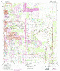
1973 Map of Bee Ridge
USGS Topo · Published 1988About this map
The growing settlement of Fruitville and the established neighborhood of Bee Ridge anchor this coastal Florida landscape during a period of rapid suburban expansion. Photogrammetric updates from the mid-1980s highlight urban encroachment into formerly agricultural lands, marked by the sprawl of new residential streets like Calliandra Dr and Honore Avenue. The landscape retains traces of its older rural character, seen in the drainage of Philippi Creek and the southern Cow Pen Slough. Educational and civic life is centered at the McIntosh Student Center and Sarasota Sch, while local history is preserved at the Palms Memorial Park Gardens (Cemetery) and the County Cem. The corridor along the CSX rail line and the development of Lake Sarasota illustrate the transition from a citrus and ranching economy toward a modernized residential hub.
Find a feature on this map
56 named features on this map. Tap any name to fly to it.
Don’t see what you’re looking for? This feature index may not catch every label — zoom into the map to look around manually.
Map Details
Editions of this 1973 Bee Ridge Map
3 editions found
Other maps of this area

1943 · Laurel
USGS Topo · 1:24,000

1944 · Bird Keys
USGS Topo · 1:31,680

1944 · Sarasota
USGS Topo · 1:31,680

1944 · Lower Myakka Lake
USGS Topo · 1:31,680

1944 · Verna
USGS Topo · 1:31,680

1944 · Laurel
USGS Topo · 1:31,680

1944 · Lorraine
USGS Topo · 1:31,680

1944 · Miakka
USGS Topo · 1:31,680

1947 · Bradenton
USGS Topo · 1:24,000

1947 · Bee Ridge
USGS Topo · 1:24,000