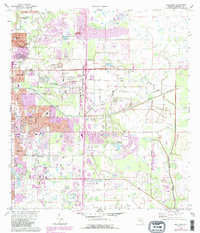
1973 Map of Bee Ridge
USGS Topo · Published 1988About this map
Sarasota and its eastern suburbs are shown during a period of significant growth, with purple revision tints marking the expansion of residential tracts into former agricultural lands. The landscape is structured by a grid of major thoroughfares like Bee Ridge Road and Bahia Vista Street, which connect established communities like Fruitville and Sunnyland. Local history and genealogy are anchored by the Palms Memorial Park Gardens (Cemetery) and a County Cem, while the cultural life of the early 1970s is reflected in landmarks such as the Drive-in Theater and the McIntosh Student Center. Water management is evident through the winding course of Philippe Creek and the southern drainage of Cow Pen Slough. Industrial and recreational interests coexist, from the CSX rail line and various sand and gravel pits to the several golf courses that punctuate the developing suburban landscape.
Find a feature on this map
54 named features on this map. Tap any name to fly to it.
Don’t see what you’re looking for? This feature index may not catch every label — zoom into the map to look around manually.
Map Details
Editions of this 1973 Bee Ridge Map
3 editions found
Other maps of this area

1943 · Laurel
USGS Topo · 1:24,000

1944 · Bird Keys
USGS Topo · 1:31,680

1944 · Sarasota
USGS Topo · 1:31,680

1944 · Lower Myakka Lake
USGS Topo · 1:31,680

1944 · Verna
USGS Topo · 1:31,680

1944 · Laurel
USGS Topo · 1:31,680

1944 · Lorraine
USGS Topo · 1:31,680

1944 · Miakka
USGS Topo · 1:31,680

1947 · Bradenton
USGS Topo · 1:24,000

1947 · Bee Ridge
USGS Topo · 1:24,000