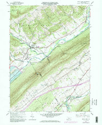
1967 Map of Beech Creek
USGS Topo · Published 1973About this map
Foster Joseph Sayers Lake dominates the central valley floor, a significant reservoir formed by the Foster Joseph Sayers Dam that reshaped the local landscape in the late 1960s. This survey, updated in the early 1970s, captures the intersection of water management and rural Pennsylvania life along the Bald Eagle Creek corridor. The geography is defined by the massive ridge of Bald Eagle Mountain, which separates the northern creek valleys from Nittany Valley to the south. Small settlements like Beech Creek and Blanchard sit at the foot of these ridges, while the Penn Central rail line follows the valley floor. Local heritage is preserved in sites like the Hays-Fearon Cem and Liberty Ch, alongside industrial markers like the Lamar National Fish Hatchery and several active quarries. The map illustrates a region transitioning between traditional agriculture and modern infrastructure projects.
Find a feature on this map
61 named features on this map. Tap any name to fly to it.
Don’t see what you’re looking for? This feature index may not catch every label — zoom into the map to look around manually.
Map Details
Editions of this 1967 Beech Creek Map
3 editions found
Other maps of this area

1921 · Howard
USGS Topo · 1:48,000

1921 · Lock Haven
USGS Topo · 1:62,500

1923 · Howard
USGS Topo · 1:62,500

1923 · Lock Haven
USGS Topo · 1:62,500

1924 · Centre Hall
USGS Topo · 1:62,500

1929 · Centre Hall
USGS Topo · 1:62,500

1937 · Millheim
USGS Topo · 1:48,000

1941 · Millheim
USGS Topo · 1:62,500

1943 · Lewistown
USGS Topo · 1:125,000

1944 · Lock Haven
USGS Topo · 1:62,500