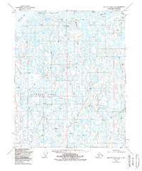
1955 Map of Beechey Point B-5
USGS Topo · Published 1988About this map
The Kuparuk River delta and the marshy coast of the Beaufort Sea dominate this landscape, reflecting a pivotal era of industrial expansion on the North Slope. Mapped in the mid-1950s with later updates, the area shows the early infrastructure of the Oil Field, marked by numerous Drill Holes and isolated Oil Wells. The terrain is defined by its arctic hydrology, where the Ugnuravik River winds through a complex network of thaw lakes and coastal features like Simpson Lagoon.
Find a feature on this map
23 named features on this map. Tap any name to fly to it.
Don’t see what you’re looking for? This feature index may not catch every label — zoom into the map to look around manually.
Map Details
Editions of this 1955 Beechey Point B-5 Map
2 editions found

Other maps of this area

1951 · Harrison Bay
USGS Topo · 1:250,000

1951 · Beechey Point
USGS Topo · 1:250,000

1955 · Harrison Bay
USGS Topo · 1:250,000

1955 · Beechey Point
USGS Topo · 1:250,000

1955 · Harrison Bay C-1
USGS Topo · 1:63,360
1955 · Beechey Point C-4
USGS Topo · 1:63,360

1955 · Beechey Point B-4
USGS Topo · 1:63,360

1955 · Harrison Bay B-1
USGS Topo · 1:63,360

1955 · Beechey Point A-5
USGS Topo · 1:63,360

1955 · Beechey Point A-4
USGS Topo · 1:63,360