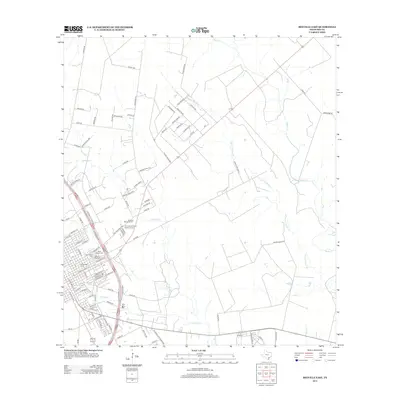
2013 Map of Beeville East
USGS Topo · Published 2013About this map
Gleenwood Cem and Evergreen Cem anchor the southeastern edge of this Bee County landscape, illustrating the concentration of local heritage sites on the outskirts of the primary settlement. The terrain is defined by a dendritic network of drainages including Poesta Cr and Talpacate Cr, which shape the rural road grid and development patterns of neighborhoods like Hidden Acres. In addition to religious landmarks such as Saint Joseph Cem and Saint Rose Cem, the map shows the spatial layout of modern infrastructure, including the Beeville Memorial Park and a variety of family-named rural routes like Keillman Rd and Dickerson Rd. Further east, the landscape opens into larger tracts of land drained by Medio Cr and Parker Hollow Cr, preserving the agricultural character of the region.
Find a feature on this map
101 named features on this map. Tap any name to fly to it.
Don’t see what you’re looking for? This feature index may not catch every label — zoom into the map to look around manually.
Map Details
Editions of this 2013 Beeville East Map
This is the sole edition of this map. No revisions or reprints were ever made.
Other maps of this area

1936 · Pettus
USGS Topo · 1:62,500

1953 · Beeville
USGS Topo · 1:250,000

1954 · Skidmore
USGS Topo · 1:62,500

1954 · Fleming
USGS Topo · 1:62,500

1956 · Beeville
USGS Topo · 1:250,000

1956 · Pettus
USGS Topo · 1:62,500

1960 · Beeville
USGS Topo · 1:250,000
1963 · Tuleta
USGS Topo · 1:24,000

1963 · Lazy F Ranch
USGS Topo · 1:24,000

1963 · Berclair
USGS Topo · 1:24,000
Featured Places
- Beeville, TX
- 1st, 2nd, and 3rd Street Area Colonia, TX
- Hidden Acres Colonia, TX
- Old Houston Highway Colonia, TX
- Bee County, TX