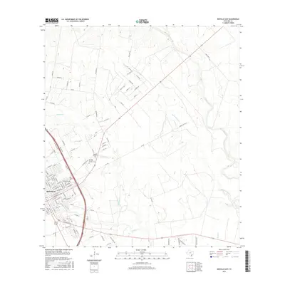
2016 Map of Beeville East
USGS Topo · Published 2016About this map
Beeville anchors the southwestern portion of this South Texas landscape, where the urban grid meets a network of rural routes and winding waterways. The town's historic continuity is visible through a significant cluster of burial grounds, including the Saint Joseph Cem, Glenwood Cem, and Evergreen Cem, providing essential points of interest for genealogists tracing South Texas families. These sites sit near the junction of several drainage systems, most notably the meandering Poesta Cr and Talpacate Cr.
Find a feature on this map
98 named features on this map. Tap any name to fly to it.
Don’t see what you’re looking for? This feature index may not catch every label — zoom into the map to look around manually.
Map Details
Editions of this 2016 Beeville East Map
This is the sole edition of this map. No revisions or reprints were ever made.
Other maps of this area

1936 · Pettus
USGS Topo · 1:62,500

1953 · Beeville
USGS Topo · 1:250,000

1954 · Skidmore
USGS Topo · 1:62,500

1954 · Fleming
USGS Topo · 1:62,500

1956 · Beeville
USGS Topo · 1:250,000

1956 · Pettus
USGS Topo · 1:62,500

1960 · Beeville
USGS Topo · 1:250,000
1963 · Tuleta
USGS Topo · 1:24,000

1963 · Lazy F Ranch
USGS Topo · 1:24,000

1963 · Berclair
USGS Topo · 1:24,000
Featured Places
- Beeville, TX
- 1st, 2nd, and 3rd Street Area Colonia, TX
- Hidden Acres Colonia, TX
- Old Houston Highway Colonia, TX
- Bee County, TX