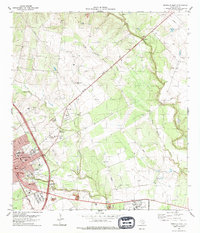
1979 Map of Beeville East
USGS Topo · Published 1979About this map
Beeville serves as the focal point of this 1970s survey, showing a landscape defined by the intersection of South Texas ranching country and military infrastructure. The town's historic core, marked by the central Courthouse, is flanked by several significant burial grounds including Evergreen Cem and St Joseph Cem. To the east, the sprawling Naval Air Station Chase Field dominates the terrain, featuring its own dedicated Golf Course and military facilities. The Southern Pacific railroad cuts a diagonal path through the countryside, passing the small settlement of Poesta and the Texas A&M University Agricultural Research Station. Drainage for the region is provided by Medio Creek and the meandering Poesta Creek, while numerous Gravel Pits suggest the area's ongoing extractive industry during this era.
Find a feature on this map
27 named features on this map. Tap any name to fly to it.
Don’t see what you’re looking for? This feature index may not catch every label — zoom into the map to look around manually.
Map Details
Editions of this 1979 Beeville East Map
This is the sole edition of this map. No revisions or reprints were ever made.
Other maps of this area

1936 · Pettus
USGS Topo · 1:62,500

1953 · Beeville
USGS Topo · 1:250,000

1954 · Skidmore
USGS Topo · 1:62,500

1954 · Fleming
USGS Topo · 1:62,500

1956 · Beeville
USGS Topo · 1:250,000

1956 · Pettus
USGS Topo · 1:62,500

1960 · Beeville
USGS Topo · 1:250,000
1963 · Tuleta
USGS Topo · 1:24,000

1963 · Lazy F Ranch
USGS Topo · 1:24,000

1963 · Berclair
USGS Topo · 1:24,000
Featured Places
- Beeville, TX
- Old Houston Highway Colonia, TX
- 1st, 2nd, and 3rd Street Area Colonia, TX
- Hidden Acres Colonia, TX
- Bee County, TX