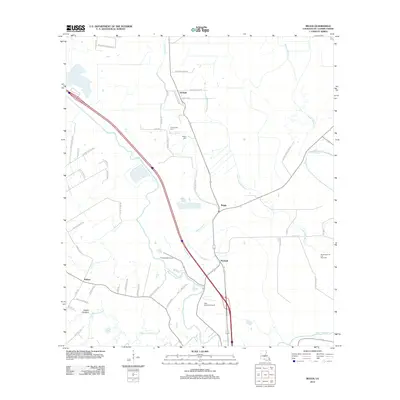
2012 Map of Beggs
USGS Topo · Published 2012About this map
Bayou Boeuf meanders through this portion of St. Landry Parish, anchoring a landscape defined by traditional Louisiana bayous and agricultural plantations. The settlement of Beggs sits near the center of the sheet, while Garland and Macland line the northern and southern corridors. Local family history is preserved at the Chimleyville Cem and Whipp Cem, providing significant touchpoints for genealogists researching the area. The presence of Thistlethwaite Camp and the Washington Oil and Gas Field indicates a mix of timber, conservation, and resource extraction that shaped the local economy. Beyond the main settlements, the terrain is marked by smaller waterways like Little Wauksha Bayou and Bayou Cocodrie, along with aviation activity at the Star Dusters Airport. The road network, including Mistrose Plantation Rd and Garland Station Rd, hints at the historical agrarian transit patterns of the parish.
Find a feature on this map
53 named features on this map. Tap any name to fly to it.
Don’t see what you’re looking for? This feature index may not catch every label — zoom into the map to look around manually.
Map Details
Editions of this 2012 Beggs Map
This is the sole edition of this map. No revisions or reprints were ever made.
Other maps of this area

1939 · Opelousas
USGS Topo · 1:62,500

1948 · Bunkie
USGS Topo · 1:62,500

1952 · Lake Charles
USGS Topo · 1:250,000

1954 · Lake Charles
USGS Topo · 1:250,000

1954 · Baton Rouge
USGS Topo · 1:250,000

1955 · Odenburg
USGS Topo · 1:62,500

1956 · Opelousas
USGS Topo · 1:62,500

1956 · Baton Rouge
USGS Topo · 1:250,000

1957 · Opelousas
USGS Topo · 1:62,500

1959 · Palmetto
USGS Topo · 1:62,500