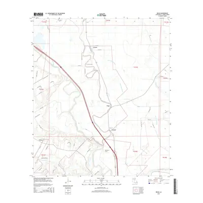
2015 Map of Beggs
USGS Topo · Published 2015About this map
Bayou Boeuf and Bayou Cocodrie define the intricate drainage patterns of St. Landry Parish, where watercourses dictate the historical placement of settlements like Garland and Beggs. The landscape is a network of bayous and coulees, including Bayou Courtableau and Coulee Garrigue, which traverse the alluvial plains of central Louisiana. This 2015 survey shows a rural environment where agriculture and water management remain central to the local geography. Local history and genealogy interests are well-served by the inclusion of several burial grounds, such as Saint Josephs Cem in the north and Chimleyville Cem and Whipp Cem near the central bayous. Small community centers like Macland and Soileau are connected by a grid of named rural roads, including Mott Rd and Plant Rd, while the Star Dusters Airport highlights modern utility within this traditional bayou landscape.
Find a feature on this map
57 named features on this map. Tap any name to fly to it.
Don’t see what you’re looking for? This feature index may not catch every label — zoom into the map to look around manually.
Map Details
Editions of this 2015 Beggs Map
This is the sole edition of this map. No revisions or reprints were ever made.
Other maps of this area

1939 · Opelousas
USGS Topo · 1:62,500

1948 · Bunkie
USGS Topo · 1:62,500

1952 · Lake Charles
USGS Topo · 1:250,000

1954 · Lake Charles
USGS Topo · 1:250,000

1954 · Baton Rouge
USGS Topo · 1:250,000

1955 · Odenburg
USGS Topo · 1:62,500

1956 · Opelousas
USGS Topo · 1:62,500

1956 · Baton Rouge
USGS Topo · 1:250,000

1957 · Opelousas
USGS Topo · 1:62,500

1959 · Palmetto
USGS Topo · 1:62,500