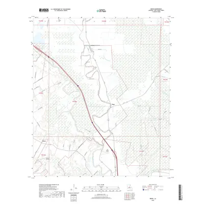
2018 Map of Beggs
USGS Topo · Published 2018About this map
Bayou Boeuf and Bayou Cocodrie dominate this St. Landry Parish landscape, illustrating the intricate network of waterways that define the region's agricultural and physical character. The 2018 survey reveals a pattern of dispersed settlements and family-named routes, such as Heard Sylvester Rd and George Ballard, which reflect a deep-rooted local history. Small communities like Beggs, Garland, and Soileau serve as anchor points amidst a grid of bayous and coulees, including the winding Little Wauksha Bayou and Coulee Garrigue.
Find a feature on this map
57 named features on this map. Tap any name to fly to it.
Don’t see what you’re looking for? This feature index may not catch every label — zoom into the map to look around manually.
Map Details
Editions of this 2018 Beggs Map
This is the sole edition of this map. No revisions or reprints were ever made.
Other maps of this area

1939 · Opelousas
USGS Topo · 1:62,500

1948 · Bunkie
USGS Topo · 1:62,500

1952 · Lake Charles
USGS Topo · 1:250,000

1954 · Lake Charles
USGS Topo · 1:250,000

1954 · Baton Rouge
USGS Topo · 1:250,000

1955 · Odenburg
USGS Topo · 1:62,500

1956 · Opelousas
USGS Topo · 1:62,500

1956 · Baton Rouge
USGS Topo · 1:250,000

1957 · Opelousas
USGS Topo · 1:62,500

1959 · Palmetto
USGS Topo · 1:62,500