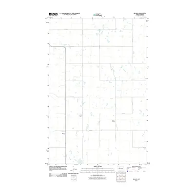
2011 Map of Belden
USGS Topo · Published 2011About this map
Belden serves as the primary point of settlement in this northern Plains landscape, situated amidst a dense network of prairie potholes and wetlands in Mountrail County. This 2011 survey by the U.S. Geological Survey captures the region's agricultural character, defined by a rigid grid of gravel roads such as 79th Ave NW and 57th St NW. The map reveals important community sites, including Bethany Cemetery and Belden Field, which provide focal points for local history and genealogy. The terrain is characterized by numerous small, scattered bodies of water that punctuate the section lines, reflecting the unique glacial topography of the North Dakota landscape during the early 21st century.
Find a feature on this map
15 named features on this map. Tap any name to fly to it.
Don’t see what you’re looking for? This feature index may not catch every label — zoom into the map to look around manually.
Map Details
Editions of this 2011 Belden Map
This is the sole edition of this map. No revisions or reprints were ever made.
Other maps of this area

1953 · Williston
USGS Topo · 1:250,000

1957 · Williston
USGS Topo · 1:250,000

1969 · Stanley
USGS Topo · 1:24,000

1969 · Stanley SE
USGS Topo · 1:24,000

1981 · Belden SW
USGS Topo · 1:24,000
1981 · Belden SE
USGS Topo · 1:24,000

1981 · Stanley SE
USGS Topo · 1:24,000

1981 · Palermo
USGS Topo · 1:24,000
1981 · Epworth
USGS Topo · 1:24,000
1981 · Epworth NW
USGS Topo · 1:24,000