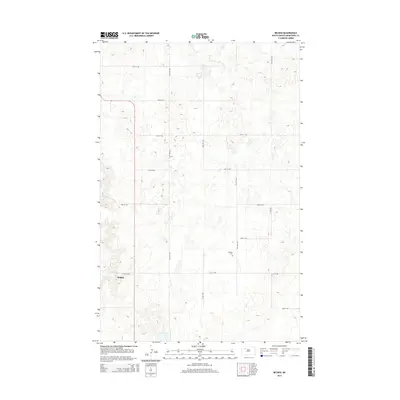
2014 Map of Belden
USGS Topo · Published 2014About this map
Belden serves as the primary focal point of this Mountrail County landscape, situated amidst a complex network of glacial potholes and prairie wetlands. The settlement is located in the southwestern portion of the map, where the terrain begins to transition from the high prairie plateau. A strictly organized grid of sectional roads, including 79th Ave NW and 51st St NW, defines the rural movement patterns across the township lines. To the east, the Bethany Cem stands as a significant landmark for genealogical research, situated near the intersection of 77th Ave NW and 52nd St NW. This 2014 survey documents the persistence of small rural hubs in North Dakota, where isolated landmarks and cemeteries remain the primary identifiers of the local community structure.
Find a feature on this map
14 named features on this map. Tap any name to fly to it.
Don’t see what you’re looking for? This feature index may not catch every label — zoom into the map to look around manually.
Map Details
Editions of this 2014 Belden Map
This is the sole edition of this map. No revisions or reprints were ever made.
Other maps of this area

1953 · Williston
USGS Topo · 1:250,000

1957 · Williston
USGS Topo · 1:250,000

1969 · Stanley
USGS Topo · 1:24,000

1969 · Stanley SE
USGS Topo · 1:24,000

1981 · Belden SW
USGS Topo · 1:24,000
1981 · Belden SE
USGS Topo · 1:24,000

1981 · Stanley SE
USGS Topo · 1:24,000

1981 · Palermo
USGS Topo · 1:24,000
1981 · Epworth
USGS Topo · 1:24,000
1981 · Epworth NW
USGS Topo · 1:24,000