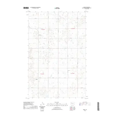
2020 Map of Belden
USGS Topo · Published 2020About this map
Belden serves as the primary focal point of this Mountrail County landscape, situated along the intersection of Belden Rd and local section lines. This modern survey reflects the enduring grid-based settlement pattern of North Dakota, where a network of numbered routes like 57th St NW and 79th Ave NW crisscrosses the high plains. Genealogists and local historians will find the locations of Knife River Lutheran Cem and Bethany Cem preserved here, serving as quiet landmarks of the community's early ecclesiastical history. The map also delineates the township boundaries for t155n r91w and t155n r90w, showing a terrain dotted with numerous small wetlands and basins typical of the region's prairie pothole geography.
Find a feature on this map
23 named features on this map. Tap any name to fly to it.
Don’t see what you’re looking for? This feature index may not catch every label — zoom into the map to look around manually.
Map Details
Editions of this 2020 Belden Map
This is the sole edition of this map. No revisions or reprints were ever made.
Other maps of this area

1953 · Williston
USGS Topo · 1:250,000

1957 · Williston
USGS Topo · 1:250,000

1969 · Stanley
USGS Topo · 1:24,000

1969 · Stanley SE
USGS Topo · 1:24,000

1981 · Belden SW
USGS Topo · 1:24,000
1981 · Belden SE
USGS Topo · 1:24,000

1981 · Stanley SE
USGS Topo · 1:24,000

1981 · Palermo
USGS Topo · 1:24,000
1981 · Epworth
USGS Topo · 1:24,000
1981 · Epworth NW
USGS Topo · 1:24,000