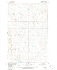
1981 Map of Belden
USGS Topo · Published 1981About this map
Glacial prairie potholes and wetland depressions dominate this portion of Mountrail County, organized under the townships of Purcell, Burke, Sikes, and Austin. The small settlement of Belden serves as a focal point in the southwestern quadrant, surrounded by a landscape increasingly managed for conservation, as seen in the expansive National Waterfowl Production Area. This conservation effort reflects the region's importance to migratory bird populations within the Central Flyway.
Find a feature on this map
11 named features on this map. Tap any name to fly to it.
Don’t see what you’re looking for? This feature index may not catch every label — zoom into the map to look around manually.
Map Details
Editions of this 1981 Belden Map
This is the sole edition of this map. No revisions or reprints were ever made.
Other maps of this area

1953 · Williston
USGS Topo · 1:250,000

1957 · Williston
USGS Topo · 1:250,000

1969 · Stanley
USGS Topo · 1:24,000

1969 · Stanley SE
USGS Topo · 1:24,000

1981 · Belden SW
USGS Topo · 1:24,000
1981 · Belden SE
USGS Topo · 1:24,000

1981 · Stanley SE
USGS Topo · 1:24,000

1981 · Palermo
USGS Topo · 1:24,000
1981 · Epworth
USGS Topo · 1:24,000
1981 · Epworth NW
USGS Topo · 1:24,000