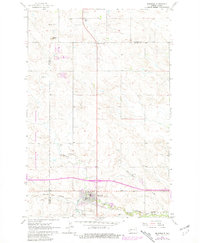
1962 Map of Belfield
USGS Topo · Published 1981About this map
Belfield stands at the intersection of the Burlington Northern railroad and regional transit ways, serving as a hub near the eastern edge of the Little Missouri National Grassland. The landscape is defined by the winding course of the Heart River and Coal Creek, which cut through the North Dakota plains. Evidence of the local extraction economy is visible in the numerous Scoria Pits and various Mines scattered across the township, particularly near the Billings and Stark County line.
Find a feature on this map
19 named features on this map. Tap any name to fly to it.
Don’t see what you’re looking for? This feature index may not catch every label — zoom into the map to look around manually.
Map Details
Editions of this 1962 Belfield Map
2 editions found
Other maps of this area

1953 · Dickinson
USGS Topo · 1:250,000

1953 · Watford City
USGS Topo · 1:250,000

1957 · Dickinson
USGS Topo · 1:250,000

1957 · Watford City
USGS Topo · 1:250,000

1962 · Fryburg NE
USGS Topo · 1:24,000

1962 · Belfield NE
USGS Topo · 1:24,000

1962 · Belfield SW
USGS Topo · 1:24,000

1962 · Fryburg
USGS Topo · 1:24,000

1962 · Belfield
USGS Topo · 1:24,000

1962 · Belfield SE
USGS Topo · 1:24,000