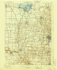
1915 Map of Bellefontaine
USGS Topo · Published 1940About this map
Indian Lake dominates the northern reaches of this Logan County landscape, its shoreline dotted with islands like Orchard Island and Wolf Island during the mid-1910s. The regional economy is clearly defined by the intersection of major rail lines, including the Ohio Electric Line and the Cleveland Cincinnati Chicago and St Louis RR, which connect agricultural hubs like Huntsville and Degraff to the county seat at Bellefontaine.
Find a feature on this map
88 named features on this map. Tap any name to fly to it.
Don’t see what you’re looking for? This feature index may not catch every label — zoom into the map to look around manually.
Map Details
Editions of this 1915 Bellefontaine Map
3 editions found
Other maps of this area

1906 · Lima
USGS Topo · 1:62,500

1913 · Alger
USGS Topo · 1:48,000

1913 · Bellefontaine
USGS Topo · 1:48,000

1913 · Sidney
USGS Topo · 1:62,500

1913 · East Liberty
USGS Topo · 1:62,500

1914 · Troy
USGS Topo · 1:62,500

1914 · St. Paris
USGS Topo · 1:62,500

1914 · Mechanicsburg
USGS Topo · 1:62,500

1915 · Alger
USGS Topo · 1:62,500

1915 · Bellefontaine
USGS Topo · 1:62,500