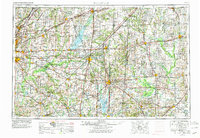
1958 Map of Belleville
USGS Topo · Published 1978About this map
Scott AFB anchors the western edge of this landscape, a vital military installation situated between the expanding settlements of Belleville and O'Fallon. This late-1950s record, updated in the 1970s, captures Southern Illinois at a peak of industrial and infrastructural transformation. The emergence of major water projects is evident in the expansive Carlyle Lake and Rend Lake, which reshaped the geography of the Kaskaskia River and Big Muddy River basins.
Find a feature on this map
82 named features on this map. Tap any name to fly to it.
Don’t see what you’re looking for? This feature index may not catch every label — zoom into the map to look around manually.
Map Details
Editions of this 1958 Belleville Map
3 editions found

Other maps of this area

1888 · St. Louis
USGS Topo · 1:62,500

1903 · New Harmony
USGS Topo · 1:62,500

1903 · Patoka
USGS Topo · 1:125,000

1904 · Mount Carmel
USGS Topo · 1:62,500

1905 · Eldorado
USGS Topo · 1:62,500

1905 · New Haven
USGS Topo · 1:62,500

1906 · New Haven
USGS Topo · 1:62,500

1906 · Eldorado
USGS Topo · 1:62,500

1906 · Breese
USGS Topo · 1:62,500

1907 · Breese
USGS Topo · 1:62,500