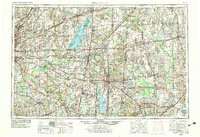
1958 Map of Belleville
USGS Topo · Published 1978About this map
Scott Afb serves as a major landmark on the western edge of this Southern Illinois landscape, which transitioned significantly during the mid-20th century with the creation of major reservoirs. The impoundment of the Kaskaskia River to form Carlyle Lake and the flooding of the Big Muddy basin for Rend Lake altered the local topography, creating new shorelines now preserved by Eldon Hazlett St Pk and Wayne Fitzgerrell State Park.
Find a feature on this map
52 named features on this map. Tap any name to fly to it.
Don’t see what you’re looking for? This feature index may not catch every label — zoom into the map to look around manually.
Map Details
Editions of this 1958 Belleville Map
3 editions found

Other maps of this area

1888 · St. Louis
USGS Topo · 1:62,500

1903 · New Harmony
USGS Topo · 1:62,500

1903 · Patoka
USGS Topo · 1:125,000

1904 · Mount Carmel
USGS Topo · 1:62,500

1905 · Eldorado
USGS Topo · 1:62,500

1905 · New Haven
USGS Topo · 1:62,500

1906 · New Haven
USGS Topo · 1:62,500

1906 · Eldorado
USGS Topo · 1:62,500

1906 · Breese
USGS Topo · 1:62,500

1907 · Breese
USGS Topo · 1:62,500