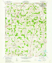
1961 Map of Bellville
USGS Topo · Published 1962About this map
The Treaty Line serves as a major historical boundary on this 1961 survey, separating the Congress Lands to the north from the United States Military District to the south. This division shapes the local landscape where Bellville sits along the Clear Fork river, anchored by its Sewage Disposal plant and the Baltimore and Ohio railroad. The map reveals a dense network of rural life, with family-named landmarks like Schweitzer Hill and essential community hubs including the Lutheran Ch, Pleasant Grove Ch, and a Grange Hall. Small settlements like Ankenytown, Batemantown, and Bangorville dot the crossroads, while the State Conservation Area and Lake View highlight the importance of the Kokosing River and its tributaries to the regional geography. For those tracing local lineage, several burying grounds are noted, including Strong Cem, Quaker Cem, and various unnamed Cem sites.
Find a feature on this map
49 named features on this map. Tap any name to fly to it.
Don’t see what you’re looking for? This feature index may not catch every label — zoom into the map to look around manually.
Map Details
Editions of this 1961 Bellville Map
Other maps of this area

1912 · Gambier
USGS Topo · 1:62,500

1912 · Perrysville
USGS Topo · 1:62,500

1914 · Gambier
USGS Topo · 1:62,500

1915 · Perrysville
USGS Topo · 1:62,500

1915 · Shauck
USGS Topo · 1:62,500

1915 · Fredericktown
USGS Topo · 1:62,500

1943 · Shauck
USGS Topo · 1:62,500

1943 · Gambier
USGS Topo · 1:62,500

1943 · Fredericktown
USGS Topo · 1:62,500

1944 · Perrysville
USGS Topo · 1:62,500