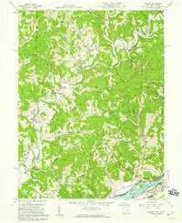
1958 Map of Belmont
USGS Topo · Published 1960About this map
The Little Muskingum River winds through a landscape defined by small rural settlements and a persistent extraction economy in the late 1950s. Located along the border of Ohio and West Virginia, this area is characterized by scattered communities such as Sitka, Moss Run, and Newell Run, each centered around family-named landmarks and local institutions like Moss Run Ch and Grange Hall. The map reveals a high density of small burial grounds, including Old Dutch Cem and Ludwig Cem, which reflect the generations of families that settled these narrow valleys and ridges.
Find a feature on this map
69 named features on this map. Tap any name to fly to it.
Don’t see what you’re looking for? This feature index may not catch every label — zoom into the map to look around manually.
Map Details
Editions of this 1958 Belmont Map
2 editions found
Other maps of this area

1903 · Macksburg
USGS Topo · 1:62,500

1904 · Marietta
USGS Topo · 1:62,500

1905 · New Matamoras
USGS Topo · 1:62,500

1905 · Macksburg
USGS Topo · 1:62,500

1906 · Saint Marys
USGS Topo · 1:62,500

1924 · St Marys
USGS Topo · 1:62,500

1924 · New Matamoras
USGS Topo · 1:62,500

1924 · Marietta
USGS Topo · 1:62,500

1926 · New Matamoras
USGS Topo · 1:62,500

1927 · Marietta
USGS Topo · 1:62,500