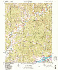
1994 Map of Belmont
USGS Topo · Published 1998About this map
Wayne National Forest dominates the interior of this landscape, where the deeply incised valleys of the Little Muskingum River and its numerous tributaries create a dense network of ridges and hollows. The river's winding path is flanked by small settlements such as Sitka and Moss Run, while the higher ground of Zion Ridge and Hog Ridge reveals the region's industrial footprint through scattered oil fields and a Strip Mine. Local heritage is preserved in several small community centers, including Lawrence School and the Lawrence Church.
Find a feature on this map
70 named features on this map. Tap any name to fly to it.
Don’t see what you’re looking for? This feature index may not catch every label — zoom into the map to look around manually.
Map Details
Editions of this 1994 Belmont Map
2 editions found
Other maps of this area

1903 · Macksburg
USGS Topo · 1:62,500

1904 · Marietta
USGS Topo · 1:62,500

1905 · New Matamoras
USGS Topo · 1:62,500

1905 · Macksburg
USGS Topo · 1:62,500

1906 · Saint Marys
USGS Topo · 1:62,500

1924 · St Marys
USGS Topo · 1:62,500

1924 · New Matamoras
USGS Topo · 1:62,500

1924 · Marietta
USGS Topo · 1:62,500

1926 · New Matamoras
USGS Topo · 1:62,500

1927 · Marietta
USGS Topo · 1:62,500