
1968 Map of Benavides
USGS Topo · Published 1971About this map
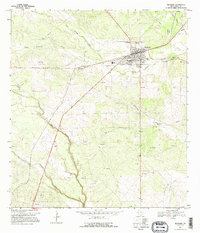
The Benavides township serves as a busy hub for the surrounding South Texas brush country, marked by a convergence of transportation and industrial activity. The Texas Mexican railroad cuts through the center of the settlement, flanked by a concentration of infrastructure including Water Tanks, a High Sch, and a local Cem. The landscape is characterized by a high density of Oil Wells and Gas Wells, indicating the region's significant role in the energy economy during the late 1960s. Several ephemeral watercourses, such as Santa Gertrudis Creek and Agua Poquita Creek, drain the terrain, which is also dotted with numerous Gravel Pits. A notable social landmark of the era is the Drive-in Theater located just north of the town center, providing a glimpse into the local recreation of the period.
Find a feature on this map
19 named features on this map. Tap any name to fly to it.
Don’t see what you’re looking for? This feature index may not catch every label — zoom into the map to look around manually.
Map Details
Editions of this 1968 Benavides Map
2 editions found
Other maps of this area

1921 · Falfurrias
USGS Topo · 1:125,000

1956 · Benavides
USGS Topo · 1:62,500

1956 · Laredo
USGS Topo · 1:250,000

1967 · Parrilla Creek SE
USGS Topo · 1:24,000

1967 · Realitos
USGS Topo · 1:24,000

1968 · Concepcion
USGS Topo · 1:24,000

1968 · Benavides NW
USGS Topo · 1:24,000

1968 · San Jose
USGS Topo · 1:24,000

1968 · Concepcion NW
USGS Topo · 1:24,000

1968 · Parrilla Creek NE
USGS Topo · 1:24,000