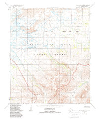
1950 Map of Bendeleben B-4
USGS Topo · Published 1988About this map
Bendeleben Mountains dominate the southern half of this mid-century survey, rising sharply above a network of waterways that define the Seward Peninsula interior. The northern landscape is characterized by extensive Lava flows, a stark geological feature that contrasts with the meandering path of the Kuzitrin River. This area is preserved within the Bering Land Bridge National Preserve, reflecting its significance in the natural history of the region. Numerous drainages such as Minnie Creek, Ella Creek, and Harris Creek cut through the terrain, illustrating the complex hydrology of this subarctic environment. The presence of the Base Line and the border of the Arctic Borough provide essential cadastral context for the remote wilderness, which remained largely devoid of established roads or permanent settlements during this period of photogrammetric mapping.
Find a feature on this map
13 named features on this map. Tap any name to fly to it.
Don’t see what you’re looking for? This feature index may not catch every label — zoom into the map to look around manually.
Map Details
Editions of this 1950 Bendeleben B-4 Map
3 editions found
Other maps of this area

1950 · Bendeleben C-5
USGS Topo · 1:63,360

1950 · Bendeleben B-5
USGS Topo · 1:63,360

1950 · Bendeleben A-4
USGS Topo · 1:63,360

1950 · Bendeleben C-3
USGS Topo · 1:63,360

1950 · Bendeleben A-5
USGS Topo · 1:63,360

1950 · Bendeleben A-3
USGS Topo · 1:63,360

1950 · Bendeleben B-4
USGS Topo · 1:63,360

1950 · Bendeleben C-4
USGS Topo · 1:63,360

1950 · Bendeleben B-3
USGS Topo · 1:63,360

1950 · Bendeleben
USGS Topo · 1:250,000