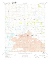
1950 Map of Bendeleben C-4
USGS Topo · Published 1979About this map
The Bering Land Bridge National Monument dominates the southern landscape of this Seward Peninsula region, preserving a stark volcanic terrain characterized by extensive lava fields. This mid-century survey captures the remote wilderness where the Continental Divide winds between the headwaters of the Goodhope River and the Noxapaga River. The geological history of the area is punctuated by distinct volcanic features such as Dryas Cone and Andromeda Cone, which rise above the surrounding tundra and wetlands. A solitary Tractor Trail provides the only mapped overland passage through the area, skirting the northern edge of the volcanic deposits and Lava Lake. This remote corridor serves as a significant drainage divide, where smaller tributaries like Esperanza Cr, Largo Creek, and Carex Creek flow toward separate coasts through a complex network of lakes including Agnes Lake.
Find a feature on this map
17 named features on this map. Tap any name to fly to it.
Don’t see what you’re looking for? This feature index may not catch every label — zoom into the map to look around manually.
Map Details
Editions of this 1950 Bendeleben C-4 Map
3 editions found
Other maps of this area

1950 · Bendeleben C-5
USGS Topo · 1:63,360

1950 · Bendeleben B-5
USGS Topo · 1:63,360

1950 · Bendeleben C-3
USGS Topo · 1:63,360

1950 · Bendeleben B-4
USGS Topo · 1:63,360

1950 · Bendeleben C-4
USGS Topo · 1:63,360

1950 · Bendeleben B-3
USGS Topo · 1:63,360

1950 · Bendeleben D-5
USGS Topo · 1:63,360

1950 · Bendeleben
USGS Topo · 1:250,000

1950 · Bendeleben D-3
USGS Topo · 1:63,360

1950 · Bendeleben D-4
USGS Topo · 1:63,360