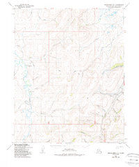
1950 Map of Bendeleben D-1
USGS Topo · Published 1988About this map
The Kugruk River watershed dominates this mid-century survey of the Seward Peninsula, revealing an economy built on remote mineral extraction and traditional routes. The presence of the Wallin Coal Mine and additional Coal Mine sites near Chicago Creek indicates a focus on fuel sourcing in the Arctic Northwest. These industrial points are connected by the Winter Trail, a vital transport corridor for a landscape defined by seasonal mobility rather than permanent road infrastructure.
Find a feature on this map
43 named features on this map. Tap any name to fly to it.
Don’t see what you’re looking for? This feature index may not catch every label — zoom into the map to look around manually.
Map Details
Editions of this 1950 Bendeleben D-1 Map
3 editions found
Other maps of this area

1950 · Kotzebue A-1
USGS Topo · 1:63,360

1950 · Bendeleben C-1
USGS Topo · 1:63,360

1950 · Bendeleben C-2
USGS Topo · 1:63,360

1950 · Bendeleben D-2
USGS Topo · 1:63,360

1950 · Bendeleben
USGS Topo · 1:250,000

1950 · Bendeleben D-1
USGS Topo · 1:63,360

1950 · Candle C-6
USGS Topo · 1:63,360

1950 · Kotzebue A-2
USGS Topo · 1:63,360

1951 · Candle
USGS Topo · 1:250,000

1951 · Selawik
USGS Topo · 1:250,000