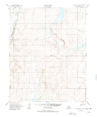
1950 Map of Bendeleben D-2
USGS Topo · Published 1978About this map
The Inmachuk River and Kugruk River dominate this interior Alaskan landscape, their winding courses carving through the Seward Peninsula during a time when remote aviation and small-scale mining defined the region's human footprint. The map reveals the presence of a Mine near the western boundary and several isolated Cabins, suggesting the persistent lure of gold or subsistence activities in this drainage basin. Transportation in this roadless area is anchored by the Utica Creek Landing Strip, a vital link for the scattered settlements in an era before modern infrastructure reached deep into the territory.
Find a feature on this map
17 named features on this map. Tap any name to fly to it.
Don’t see what you’re looking for? This feature index may not catch every label — zoom into the map to look around manually.
Map Details
Editions of this 1950 Bendeleben D-2 Map
3 editions found
Other maps of this area

1950 · Kotzebue A-1
USGS Topo · 1:63,360

1950 · Bendeleben C-1
USGS Topo · 1:63,360

1950 · Bendeleben C-3
USGS Topo · 1:63,360

1950 · Bendeleben C-2
USGS Topo · 1:63,360

1950 · Bendeleben D-2
USGS Topo · 1:63,360

1950 · Bendeleben
USGS Topo · 1:250,000

1950 · Bendeleben D-3
USGS Topo · 1:63,360

1950 · Bendeleben D-1
USGS Topo · 1:63,360

1950 · Kotzebue A-3
USGS Topo · 1:63,360

1950 · Kotzebue A-2
USGS Topo · 1:63,360